Showing posts with label Wrightwood. Show all posts

Thursday, May 29, 2008

May 24, 2008 Pacific Crest Trail

Destination: Moore's House, Wrightwood
Miles: 6


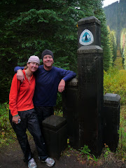
Adrian: Today we are staying with amazing trail angels Bob and Maria. They gave us their whole basement, beds and all the food and drink we could consume. Bob works for the National Forest Service so we get good updates on weather and trail conditions on demand.

We wanted to leave town today but the snow put those plans on hold. Instead, Bob drove us up to Highway 2 and the PCT so we could log at least a few miles and see what the conditions are like. We basically walked 6 PCT miles and then hiked the Acorn trail back into town for a total hike of 9 miles.

There are snowdrifts up to 3 feet deep and the average trail coverage is about 3 inches. There was thick fog and visibility was about 50 feet for most of the hike. We good gear though and cruised it.

Tomorrow we are hitting the trail northbound again. We have the option of 3 trails all at different elevations, so we can pick how much snow we want to hike in.


The PCT would take us up to 9,900 feet to the summit of Mount Baden-Powell, named after the founder of the Boy Scouts. It is a major pilgrimage for Scouts, and I was one back in the day. There are Limber pines up there that are over 2000 years old too, so obviously taking the PCT would be the best option.

The other options are hiking the closed Highway 2 at a lower elevation or the High Desert National Recreation Trail. Both would be safer than the PCT and at a significantly lower altitude.

We've heard of hikers being turned back on Baden-Powell due to icy chutes and too much snow so everything is up in the air right now. Well except for one thing, and that is that we are heading north again tomorrow.

Next stop, the Saufley's!

Kirsten: I never thought I would be making a snow angel in SoCal in May. The snow up above the town was wet and heavy and blanketed the pine trees. It was beautiful. I am still a little scared about the trail tomorrow. It rises to a higher elevation - if we follow the PCT to Baden-Powell. I know Adrian wants to take the trail. He won't push it though.

The Moore's are amazing. Maria made us lentil soup and then a yucca and green bean salad. She also made these homemade taquito-type things and a huge salad. Oh, and homemade Spanish rice. The people we've met continue to surprise me with their generosity.

Wednesday, May 28, 2008

May 23, 2008 Pacific Crest Trail

Destination: Pines Motel, Wrightwood
Miles: 0


Adrian: Usual zero day except it snowed 3 inches in town and more than 8 on the ridge. Our hike out tomorrow might be delayed due to this storm. News crews from Los Angeles were here doing live reports.

I like snow but it couldn't have come at a worse time as we are at our highest altitude between Mexico and the Sierras. Just when we make up some time, something like this happens. Such is life on the PCT.

Kirsten: Adrian's superhero trail name has rubbed off and it appears he is developing powers. Some might even call them super powers.

Adrian woke up and before jumping in the shower said, "I had this dream last night that it snowed like 4 inches up on the ridge."

Ok, so it snowed more like 5 inches and it was in town and on the ridge. But hey, what a prediction.

We spent the rest of the day talking about what we were going to do about the snow.

May 22, 2008 Pacific Crest Trail

Destination: Pines Motel, Wrightwood
Miles: 20


Adrian:
Thanks to Brian, Mike and Cathy for signing our guestbook. We appreciate the support.

We had our first rain and our first snow today. It kept us cool for the 5,500-foot climb from Interstate 15 up to Wrightwood. Our highpoint was 8,250 feet after a low point of 2,930 feet at the interstate.

It was quite cold as we reached the Acorn Trail, which was one of the ways down into Wrightwood. Because we were not sure if the hitch on Highway 2 would be easy, we opted to hike down the steep Acorn. It will be a pain to hike back up it, but we are in town!
Kirsten: Have I mentioned yet that we have trail names?

Well we do. A trail name is sort of like a nickname. Some hikers never take them on; preferring to stick with the names their parents gave them. I'm kind of indifferent to the trail name concept. I think it's fun and a lot easier to remember people. I don't call Adrian by his trail name though because it just seems weird. He's Adrian to me, not Hawkeye, which is what Fatty Cakes dubbed him a couple of weeks ago.

Why Hawkeye? Because he has a hawk's eye. Get it? He does have this gift for spotting things like animals or a cold beer in the middle of the desert (this happened outside of Warner Springs).
I think his name sounds sort of superheroish. I wonder what his superhero outfit would look like? And his lair. Would it be in a nest?

You may be wondering what my name is. For those of you who know me, this should not come as a surprise. My trail name is Danger Prone. It sort of speaks for itself. I tend to trip and fall all the time. I also punched myself in the face as I went to grab my hat on a windy traverse. I almost gave myself a black eye when I knocked a water bottle over onto my head. I was laying down at the time.

Oh yeah, this happened long before the PCT. I once drank, but DID NOT SWALLOW, denatured alcohol. To be fair it was being stored in a poorly labeled plastic water bottle.

Saturday, May 24, 2008

Snowbound in Wrightwood

Our regular journal postings will be updated over the next few days. In the meantime, here is a quick update.

We arrived in Wrightwood, a mountain town located at about 6,000 feet, on Thursday afternoon. That night a snow storm rolled into the area and by morning about three inches of fresh snow had fallen in town. More fell throughout the day and our plans to leave today (Saturday) changed.

There is a 6-mile section from the split of the Acorn Trail, which we used to drop down into the town, and Highway 2. We didn't want to waste the day and decided we might as well hike that section. We are staying with a family, the Moore's, who open up their home to hikers. Bob Moore drove us up to Highway 2/Inspiration Point and we then hiked back the six miles to the Acorn Trail. It was another three miles down the Acorn Trail into town.

Tomorrow we plan on leaving Wrightwood and may end up taking the High Desert National Recreation Trail, also known as the Manzanita Trail, for 10.4 miles before reconnecting with the PCT. Several hikers have turned back because of the snow and the Desert Trail is at a lower elevation and therefore should be passable.