Destination: Big Pete Meadow
Miles: 14
Adrian:
A huge congratulations to Billy and the best of wishes to Deanne on their wedding day today! We are so sorry to miss the special day and celebrate with all the great people at the event. We love you two! Good luck and the best of times to you two.
Today was a nice rest day with relatively easy miles to get in position for the longest pass yet; Muir Pass.
We started with a long 2,000 foot descent down the Golden Staircase. Trekking poles saved our knees here for sure. We followed a raging river down to the Middle Fork of the King's River. Once there we had a warm lunch of brown fried rice with sundried tomatoes. I caught a small Golden Trout while K cooked.
We lunched with Duece and talked about going to the High Sierra Music Festival over Independence Day. It's in Quincy, which is not far from where we'll be.
The hike up past Bishop Pass trail was an easy climb and we found a great stealth campsite about 4 miles from the summit of Muir Pass. Dinner was Mac'n'Cheese super-charged with a chicken breast mixed in. Desert was crushed Mint Milanos.
Tomorrow an early start on Muir...
Kirsten:
Two important events occurred today. First and foremost, Billy and Deanne's wedding. Our adventure has been amazing. BUT I wish we could have been at in Colorado to witness our close friends exchange vows.
OK, on to the next event. Hike Naked Day! Yup, today is hike naked day. You should see Adrian's sunburn.
Friday, July 4, 2008
Tuesday, July 1, 2008
June 20, 2008 Pacific Crest Trail
Destination: Upper Palisade Lake
Miles: 15
Adrian:
This was supposed to be a fun day but it turned out stressful and sad.
The Sierra has some of the best scenery and camping of any park I've ever visited. I must come back some time and take it in a bit slower.
Today we woke up with a few other hikers around us including Uncle Lorenzo whom we love hiking with. Since we hoped to climb two passes today we packed up and were out hiking pretty early.
The passes of the day were Pinchot, 12,130 feet, and Mather, 12,100 feet.
We positioned ourselves well the night before and only had about a 3-mile hike up to Pinchot. No problem right? Wrong. Most of the approach was snow covered and the trail very hard to find. We've had wet feet now for about 3 days straight due to hiking over snow and crossing big streams. That's right, many steams are not bridged so we walk right through them with our shoes on. Also, because of all the snowmelt, the trail is often a river itself.
We summited Pinchot Pass around 10:30 a.m. with Lorenzo not far behind. On top we were invited by him to visit Torino, his hometown. We hope to soon. The descent was snow covered and we separated from Lorenzo as we picked our way down to Lake Majorie. Upon reaching the lake I did some fishing with no luck other than a follow. The lake was choked with icebergs so maybe that had something to do with it.
Further down valley we had to ford the South Fork of the King River. It was about lower thigh high and very cold. We met Gloworm on the other side and had lunch while our things dried in the hot sun. We wondered about Lorenzo because he wasn't too far behind usually. After an hour break we began to move out for our second pass, Mather.
As we resumed our hike we came across Yak and company. Since they were behind us we asked if they had seen Lorenzo. That's when we heard the news that he had somehow injured his calf or something like that not far from where we had last seen him. His plan was to limp out to trailhead over Taboose Pass which is near 12,000 feet and over 10 miles, a tough proposition healthy, much less with an injured leg. Kirsten and I were very saddened by the news and still are concerned for our Uncle Lorenzo. He's is a very capable mountaineer though so I'm confident he'll be fine.
Lorenzo, if you read this, please get well soon and try to skip ahead after resting a few days, or even a week. Maybe get back on in Yosemite? Good luck my friend!
On to Mather with a heavy heart. The climb to the pass was easy and very scenic. Simply awesome mountains and rivers with many wet fords. Then we saw the pass itself; snow covered and steep.
We approached from the left on the trail (some kick steps up the snow slope directly below the pass) and soon hit the steep traverse up the snow slope. Steps were in place and near the top I wish I had my ice axe in hand. A fall there would have meant a 500-foot slide down the snowfield. The runout was relatively safe but risk of injury would have still been high. Kirsten did a great job even though the exposure was high.
We enjoyed the view from the top with Gloworm and then made our way down the snowy north face. Kirsten fell once and hurt her butt, but she was fine except for a bruise. At 7:20 p.m. we found a decent campsite above Upper Palisade Lake.
What a day...
Kirsten:
So ... falling. That's my job these days.
This morning we both hit the trail with an ambitious schedule - two passes in a day. The first pass went well.
Then there was Mather. The ascent made me nervous. I talked my self through it, kept my head down and kicked steps until we reached the summit. This is when the fun began. The descent was a slip n' slide carnival ride filled with endless postholing through soft snow and breaking through snow bridges into small creeklets.
Somehow Adrian floated on top while I wallowed in the dredges. And then I fell. And then I fell again. And again.
When we finally made it to a dry campsite I was a bit pissy and hungry. My mood improved with a hot meal and I was sitting in the tent about to fall asleep when I spotted a mammoth mule deer buck silently walk by. In that one moment I forgot all about my bruised butt and tendency to fall every five seconds.
June 19, 2008 Pacific Crest Trail
Destination: Twin Lakes, King's Canyon N.P
Miles: 15.5
Adrian:
Today we slept in because there was no need to rush to get to Glen Pass early. The pass has a fair amount of snow on it that is very slippery when frozen solid after a long night, hence, no rush.
Glen Pass, at 11,978 feet, is known to many as the most treacherous on the PCT, so we would wait until 10:30 a.m. to hike the steepest parts.
The ascent wound through dark azure alpine lakes still choked with icebergs. Snowmelt streams were abundant so we never carried more than a half a liter. You can't see the switchbacks zigzagging up the improbable cliff until you are very close to them. The trail was good and we sped up it in fine style.
Lorenzo, 57, is from Torino and is now being called Uncle Lorenzo on the trail was on top to greet us. The view was great down to Sixty Lakes Basin and Rae Lakes.
The way down started with a steep traverse over snow, maybe an eighth of a mile long with big exposure. A fall here would have dire consequences. The rest was intermittent snowfields and rock ridges. We made it down safely and took a break at beautiful Rae Lakes.
Continuing down the valley towards Woods Creek we stopped at Dollar Lake to fish. We caught Golden Trout, the state fish of California, on every cast. They are such beautiful fish, not very big, but golden brown with bright pink spots and a fluorescent orange underbelly. We fished for about an hour before the mosquitoes drove us off.
The rest of the day we hiked down a long valley next to a river I don't know the name of, to Woods Creek. It had a great suspension bridge around 100 feet long over the torrent. Only one person was allowed across at a time.
King's Canyon National Park has some the best hiking I've ever seen. The scenery is simply breathtaking, ranking up there with Patagonia, Glacier National Park, and Yosemite.
I HIGHLY recommend a backpacking trip here along the John Muir Trail or any of the other great paths in the area.
This is fun...
Kirsten:
The scariest pass ... DUM, DUM, DUUUMMMMM. It turned out to be not so scary. It didn't make it any easier. The pass was still steep and snowy. My confidence with trekking through snow has increased and I think that has helped me today.
We haven't seen any bears yet and I'm starting to wonder if there are any out here.
June 18, 2008 Pacific Crest Trail
Destination: King's Canyon N.P.
Miles: 18
Adrian:
Forester Pass is more than 13,100 feet and steep. We camped about 4 miles from the summit and started hiking around 7 a.m. as to arrive early enough to prevent postholing (stepping on the snow and plunging up to the thigh) but late enough to assure the snow was not all ice from the night before. The plan worked and we summited without any issues. The switchbacks were very steep and there was only one tricky snow chute to cross. All in all, not bad.
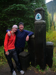
On top were about 12 other PCT thru-hikers and it was a real party. Everyone was very excited to have climbed the highest pass of them all. This is also the border of Sequoia and King's Canyon National Parks. Our second national park of the trip so far.
This is the highest point on the PCT, so technically it's all downhill to Canada :) The descent was snowy and our feet were soaked. We didn't know it at the time but our shoes haven't been dry since due to snow and deep river fords.
Tomorrow on to the scariest pass, Glen.
Kirsten:
We forded a creek the night before so this morning we awoke to frozen shoes. Ever try to put on frozen shoes? Try to avoid this scenario. The normally mundane act of putting on my shoes became a WWF match this morning.
So, my first true mountain, snow-covered pass. I was nervous coming up it. It looked hard and I was worried about the altitude. The going was slow for me. And then without warning I was on top. Just like that (snap of the fingers) my first and the highest pass was complete. On top was Gary or Drive-by, Snow Kittens, Lil Wrangler, the Deuce, who broke out his guitar for a little summit pass music, Shake n' Bake, Slow Ride and the Italian Lorenzo, who now goes by UNNNNCCCCLLLLEE LOOOORENNNZOOOOOO.
Miles: 18
Adrian:
Forester Pass is more than 13,100 feet and steep. We camped about 4 miles from the summit and started hiking around 7 a.m. as to arrive early enough to prevent postholing (stepping on the snow and plunging up to the thigh) but late enough to assure the snow was not all ice from the night before. The plan worked and we summited without any issues. The switchbacks were very steep and there was only one tricky snow chute to cross. All in all, not bad.
On top were about 12 other PCT thru-hikers and it was a real party. Everyone was very excited to have climbed the highest pass of them all. This is also the border of Sequoia and King's Canyon National Parks. Our second national park of the trip so far.
This is the highest point on the PCT, so technically it's all downhill to Canada :) The descent was snowy and our feet were soaked. We didn't know it at the time but our shoes haven't been dry since due to snow and deep river fords.
Tomorrow on to the scariest pass, Glen.
Kirsten:
We forded a creek the night before so this morning we awoke to frozen shoes. Ever try to put on frozen shoes? Try to avoid this scenario. The normally mundane act of putting on my shoes became a WWF match this morning.
So, my first true mountain, snow-covered pass. I was nervous coming up it. It looked hard and I was worried about the altitude. The going was slow for me. And then without warning I was on top. Just like that (snap of the fingers) my first and the highest pass was complete. On top was Gary or Drive-by, Snow Kittens, Lil Wrangler, the Deuce, who broke out his guitar for a little summit pass music, Shake n' Bake, Slow Ride and the Italian Lorenzo, who now goes by UNNNNCCCCLLLLEE LOOOORENNNZOOOOOO.
June 17, 2008 Pacific Crest Trail
Destination: Wright Creek, Sequoia N.P.
Miles: 6
Adrian:
Today was technically a zero day but we got a few things done. Let's see, we did get 6 trail miles done, we did get some trout fishing done (no luck but a couple strikes), oh and we did climb the highest peak in the lower 48 states of the U.S.A., Mount Whitney!
Rob, Kirsten and I woke at 5:30 a.m. and started the hike an hour later. The trail wound around Guitar Lake and made its way to the basin above. Steep switchbacks led up to the junction with the Whitney Portal Trail. It was amazing how this trail would weave into and out of the wildest towers. Kirsten was out of sight around a tower when she fell again. She reported that her trekking pole got stuck and she lost her footing. Apparently the pole almost went over the big cliff next to her.
It was about a 3,000-foot climb to the summit where the Smithsonian Hut resides for research. We took pictures, had lunch and tried but failed to get a cell phone signal. All in all, we spent an hour on top.
Rob needed to take the Portal trail down and hitch a ride to Lone Pine so we said our sad goodbyes and bid him farewell. It was great to have him along. He easily kept up with us, and except for some blisters caused by small shoes, managed the four-day hike with ease. Maybe another trip down the road, Rob?
Kirsten and I sped down the trail, broke camp, and hiked the 4 miles to the PCT and did another six on that. I did a little fishing in a stream near Timberline Lake but had no luck other than a solid strike.
Tomorrow, the highest pass on the PCT! Walk good...
Kirsten:
I'm pretty sure Adrian wrangled away Lance Armstrong's heart and lungs in a game of black jack. He practically floated up the switchbacks to Mount Whitney while my pace slackened to a slow molasses ooze. Every time I hike and hit about 13,000 feet, my body begins to reject the high altitude environment I happen to be in. I still made to the top. It was just a struggle.
Today was the first day that I even considered leaving the trail. I know why and those thoughts passed as we set up camp for the night. I've been so focused on my mini-goals, just get to Warner Springs, OK now to Idlywild and so on, that I haven't had time to get homesick. And where is home, anyway? Our house is rented, our family and friends scattered about. Adrian is my home in most ways. Still, having my brother join us for a few days abruptly swept me back into my pre-trail life. When he left the summit and began his descent, I was surprised at how emotional I was about his departure and how overwhelmed I felt at the thought of the trail ahead. Slowly, as we pushed on through more miles I fell back into my routine and started enjoying the Sierras again.
June 16, 2008 Pacific Crest Trail
Destination: Guitar Lake
Miles: 18
Adrian:
Happy birthday to our awesome niece Sierra!! We miss you and wish we were there!
Guitar Lake is an advanced base for climbing Whitney from the west side. It is possible to camp further down at Crabtree Meadows but that would make summit day almost 6 miles longer round-trip, plus the mosquitoes are much worse at Crabtree.
As I approached the campsites scattered around the lake (which actually is shaped like a guitar), I heard someone call my name, it was David. David is a good friend of Rob's friend Jigar. We had rough plans to meet here for the climb. Sometimes meetings like this work out and it's fun when they do.
We talked about the plan for tomorrow and enjoyed a jerky party sponsored by Rob. He was also very kind to give the remaining food he didn't eat to us making our remaining 7 days to Vermilion Valley Resort much more pleasant. Thanks again Rob!
Kirsten:
I finally feel like we've entered into the Sierras with its endless streams, meadows, lakes and jagged peaks. The miles were easier today. Maybe the scenery helped ease our sore muscles and lift ups our packs. Many times the last three miles up to camp - in this case, Guitar Lake - can be tiresome. Your feet have what I call little heartbeats from the non-stop pounding on rocky, dusty trail. Today was different. The pain and soreness were there. Those three miles were still more enjoyable than the last 30. The trail wound its way up amongst a boulder-littered meadow to shimmering Timberline Lake then kept to its edge before rising again to several other small tarns or lakes. The trees disappeared, the marmots became plentiful and before we knew it there was Guitar Lake surrounded on nearly every side with steep Rocky Mountains.
The amount of food Rob brought with him borders on ridiculous. I had to chuckle when I watched Rob pull out a one pound, unopened bag of jerky from his pack. He laughed at himself and immediately opened it up for all to enjoy. His overestimation has been a boon for us and any concern of a food shortage later on our journey to Vermilion Valley Resort has been eliminated.
June15, 2008 Pacific Crest Trail
Destination: Sequoia National Park boundary
Miles: 20.5
Adrian:
Today we did the miles, but they were tough. We made it to the border of Sequoia National Park and we are already seeing some huge pine trees, namely the Foxtails. They look like enormous bonsai trees.
That's all I remember because I've fallen behind on the journal. It's hard sometimes when you arrive so tired into camp all you can do is cook, eat, and sleep.
More to come, stay tuned...
Kirsten:
My pack seems no lighter than it did the day we left Kennedy Meadows. This sucks and the miles are harder than I expected because of the constant and burdensome weight on my hips and shoulders.
The second half of the day was beautiful. We stopped at a small lake for dinner before pushing on for a few more miles. Rob's blisters continue to worsen - a byproduct of too-small shoes - and I'm worried about the next two days. I know that miles can be completed. It's just they are a little less fun.
Subscribe to:
Posts (Atom)